


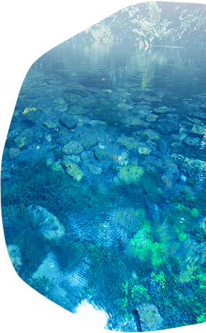
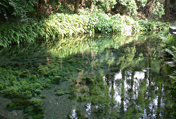
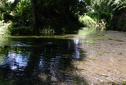
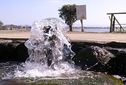
Kumamoto City, renowned throughout Japan for its pristine groundwater, is unique in being home to 700,000 people whose residential, agricultural, and industrial water supplies all rely on groundwater. Kumamoto City is located on the island of Kyushu, a region with high yearly precipitation, and lies just west of the outer ring of mountains that make up the enormous caldera of Mt. Aso. These features, combined with a very wide and deep distribution of pyroclastic flow deposits and porous lava flows (Togawa Lava) from Mt. Aso, contribute to the generation and sustainment of a truly enormous groundwater system. This groundwater is recharged in the forests and rice paddies populating the western slopes of the Mt. Aso caldera through rainwater infiltration. This then flows down to Kumamoto City via aquifer, where it reaches the ground surface through a number of springs located along the boundary of the highlands and lowlands. The most famous of these springs is found in Suizenji Park. Kumamoto Prefecture is the only prefecture in Japan in which a large-scale aquifer and the entire system of groundwater flow, from recharging to outflow, lies entirely within one prefecture.
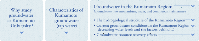
Owing to these hydrological factors, Kumamoto offers opportunities for groundwater studies in a wide variety of disciplines: groundwater flow mechanisms offer opportunities for physics research, issues such as maintenance and purification of groundwater through appropriate management activities can be studied from an engineering standpoint, and there are even opportunities for study in policy science by observing the systems that allow for continuous use of groundwater resources through effective utilization of potential recharge in the uniquely wet climate of Asia. Kumamoto also possesses the geographical advantages that make a program like GelK possible for training future environmental leaders. Kumamoto offers an ideal balance of classwork and fieldwork thanks to nearby measurement and survey locations allowing for easy work in the field, in addition to real experience observing how groundwater management policies are implemented in Kumamoto.
While Kumamoto has been known throughout history as the Land of Fire, no doubt due to the constant activity of Mt. Aso, Kumamoto Prefecture is also a land of water, boasting four locations named to the top 100 Heisei period waters in Japan and four locations in the top 100 Showa period waters as compiled by Japanese Ministry of the Environment, for a total of eight, tying Toyama Prefecture for the most in a single prefecture.
Groundwater rich in alkaline earth metal carbonates is the main source for Kumamoto City’s tap water, and it contains Ca2+, Mg2+ and Na+ ions in almost equal proportions. There has been almost no change in water quality over the past 20 years, and studies have been published showing Kumamoto’s tap water tastes even better than some bottled waters found throughout Japan (Kawagoshi et al. 2009).
The Kumamoto Region is comprised of Kumamoto City and a number of surrounding cities, towns, and villages, all of which rely 100% on groundwater for their needs. As such, protection of groundwater resources in the Kumamoto Region has been an important issue for a long time. For this purpose, tireless research into groundwater flow and the understanding of groundwater structures is constantly being performed. The following is an overview of groundwater in Kumamoto as we have come to understand it through previous research.
The hydrogeological structure of the Kumamoto Region
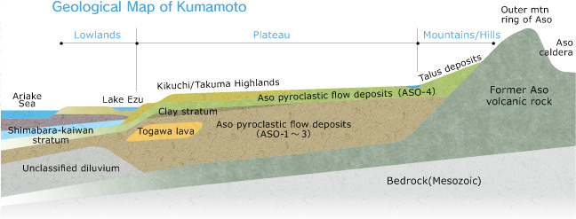
In the Kumamoto Region, the majority of the Quaternary deposit is a pyroclastic flow plateau formed from pyroclastic flow deposits that resulted from four large eruptions of Mt. Aso that occurred 90,000 to 260,000 years ago, all of which lies atop andesite and bedrock. Part of the plateau is covered by terrace deposits, but the Aso pyroclastic flow deposits (from eruptions named Aso-1, Aso-2, Aso-3, and Aso-4; in order from oldest to most recent) account for the majority of the Quaternary deposit (the newest stratum, dating from 2 million years ago to the present). This stratum is an important constituent in the Kumamoto Region aquifer, and the relatively high permeability of water into the volcanic rock, the high rainfall in the Kyushu Region, and the considerable hydraulic gradient form the hydrogeological basis for the active circulation of groundwater within the Kumamoto Region.
The groundwater that exists elsewhere in Japan resides mainly in aquifers in alluvial deposits from rivers. The slope of these aquifers (the hydraulic gradient) and the permeability of their constitutive substances are considerably different than those found in Kumamoto.
Between each of the pyroclastic flow deposit strata, there exists a distribution of deposits from periods of volcanic inactivity. Such deposits of lava rock, including Togawa lava, Oomine pyroclastic cone deposits, and Takayubaru lava form the main part of the aquifer, while lacustrine deposits, such as the Hanabusa and Futaso strata, function as areas of low permeability between aquifers.
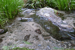
The groundwater in the Kumamoto Region is divided into two aquifers. Looking at the lacustrine strata between Aso-3 and Aso-4, the aquifer that lies above this strata, within Aso-4, is an unconfined aquifer (No.1 Aquifer). Below the lacustrine strata and consisting of pyroclastic flow deposits from Aso-1, Aso-2, and Aso-3, as well as highly-porous and densely crannied Togawa lava (found around Lake Ezu in Kumamoto City, and Shimorokka and Ukishima in Kashima Town), lies a confined aquifer (No.2 Aquifer). The main underground resources of the Kumamoto Region rely on the water supply from Aquifer #2.
Current groundwater conditions in the Kumamoto Region (decreasing water levels and the underlying factors)
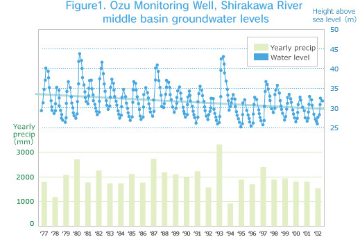
Although Kumamoto is famous as an area rich in groundwater resources, the fact is that long-term monitoring of groundwater has revealed clear downward trends in water levels. As shown in Figure 1, a chart of groundwater level data collected at the Ozu Monitoring Well located in the middle basin lowlands of the Shirakawa River, there is a 7-8m seasonal variation corresponding to maximum and minimum water levels, but a long-term decrease of about 5m every 20 years is also evident.
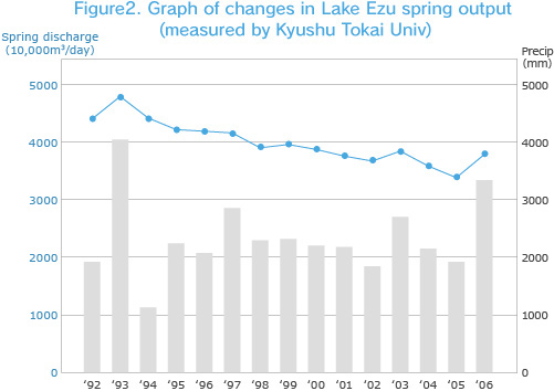
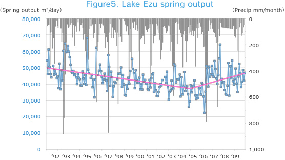
dditionally, monitoring that started in 1992 on the spring output in Lake Ezu in Kumamoto City (by Kyushu Tokai University, shown in Figure 2) indicates a decrease over the long term, with an output of approximately 500,000m3/day in 1992 decreasing to approximately 400,000m3/day in 2002, equating to a drop of 20% within 10 years. This illustrates that there is evidence for drops in water levels and decreases in spring outputs in the Kumamoto Region, leading us to understand that groundwater resources are clearly declining.
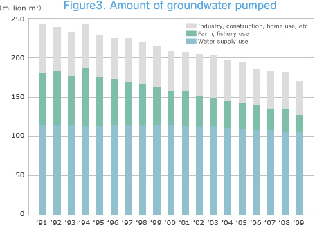
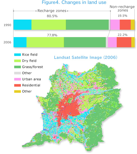
Under normal circumstances, the amount of water being pumped from the ground is assumed to be the main reason behind declining groundwater levels, yet, rather than increasing over the past few years, pumpage in Kumamoto has actually decreased, largely as a result water-saving efforts within industry and agriculture, which have resulted in a clear decline in water pumped over the 20 years shown in Figure 3. Thus, there appears to be no relationship between pumpage amounts and the decreases in available groundwater resources. What has been suggested as the cause behind the decrease in groundwater is the shrinking of the recharge zone due to urbanization, and especially the rapid disappearance of irrigated rice fields within the Shirakawa River middle basin lowlands. Figure 4 shows the spread of “non-recharge areas” within the Kumamoto Region in 2006 (indicated by warm colors). Non-recharge areas, where recharge is low, have gradually grown larger over the past 15 years.
As stated previously, the lowlands of the Shirakawa River middle basin form the main recharge zone for Aquifer No.2 Aquifer. The rice fields in this region require an extremely high volume of irrigation water due to a daily loss of water depth of about 100-200mm, or almost 10x that of the average within Japan. This is due to the prominence of highly-permeable gravel and pyroclastic flow strata, which contain which contain very little clay soil and are commonly used as soil treatment in rice fields on account of their low permeability.
Groundwater resource recovery efforts
In order for the abundant groundwater resources of the Kumamoto Region to be continuously available for use in the future, the amount of groundwater used must be reduced through water conservation efforts while simultaneously increasing the groundwater recharge areas in proportion to the amount of groundwater being pumped out.
To solve this problem, Kumamoto City, which is the largest consumer of groundwater in the region, is making progress through comprehensive groundwater management policies that focus not only on administrative regulations, but also involve a system for cooperating with rice field farmers within the Shirakawa River middle basin lowlands, an area that is so important in recharging the region’s groundwater because of its hydrogeological structure. Recent years have seen the implementation of a system of support for active, artificial groundwater recharge as a unique framework for continuously managing the groundwater resources of the Kumamoto Region. Since the start of these activities, the target areas, numbers of participating farmers, amount of money invested, etc., have grown steadily. The output of the spring in Lake Ezu, which had been in slow decline, was confirmed in 2006 to have rebounded slightly as a result of these efforts.
*Bibliography
Yasunori KAWAGOSHI, Yasuhiro IWASA, Tsutomu YUNOUE, Kaori MAEDA, Kazuo TOMIE, and Ryuji KAKIMOTO (2009): Water Quality Characterization and Evaluation of Kumamoto City Drinking Groundwater as Tasty Water. Journal of Japan Society on Water Environment, 32, 383-388.
Jun SHIMADA (2012): Sustainable groundwater management considering potential groundwater recharge in Monsoon Asia. Journal of Japanese Hydrological Sciences, Vol. 42, 33-42.
Kumamoto City, Kumamoto Prefecture (1995): Comprehensive Maintenance Management Report on Kumamoto Region Groundwater, p122.